High tide of 10.08 takes place at 2:48 this afternoon… so we may be dodging the opportunity to flood. The wind warning is in effect starting 5:00 pm tonight at which point, tides will be around 8 feet. The next high tide of 8.28 will be at 1:54 am.
Tis the season for wind, waves and rain
September 28, 2013 by Leave a Comment
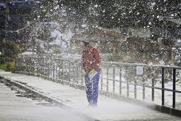
I was caught on the West Seattle Bridge late this afternoon in an amazing display of Mother Nature’s force. It was more rain, wind and water than I have ever witnessed on the bridge. I’m very glad to be home!
Sunday Morning Storm Update
September 22, 2013 by Leave a Comment
Well the first high tide took place a couple hours ago. We’re now bracing for the next high tide which is a 10.94 at 7:12 pm tonight.
Storm Update
September 21, 2013 by Leave a Comment
Weather guru Cliff Mass says the first big fall storm should start right about the time that summer is officially over, at 1:44 pm Sunday which coincides with the kick off for the Seahawks vs Jaguars at Qwest field.
NWS issues Special Weather Statement for Sunday
September 20, 2013 by Leave a Comment
Last Sunday we had “Blue Thunder” for the Seahawks game…and it looks like this Sunday will bring howling weather as the National Weather Service has issued a Special Weather Statement for the first official day of fall. It’s probably a good idea to make sure what leaves are currently around drains are cleared (although we’re going to have plenty more coming down).
Thunder storm disrupts cocktail hour on Beach Drive -THE AFTERMATH-
June 26, 2013 by Leave a Comment
On the bright side, those that didn’t reset their clocks as soon as the power returned were treated to an extra half hour! For others it was reason for concern…

I spoke to one of the guys on the job this morning about any concerns of heavy rainfall on the Atlas slide zone: “I definitely gave it a thought!”
Rhonda Porter of BDB captured these weather shots after the storm cleared

Make mine a double!

It was back to regular programming by day’s end.
Chance of thunderstorms later this afternoon according to the NOAA marine weather report
PUGET SOUND AND HOOD CANAL-
840 AM PDT WED JUN 26 2013

TODAY
S WIND 5 TO 15 KT BECOMING SW 10 TO 20 KT IN THE AFTERNOON.
WIND WAVES 1 TO 3 FT. SHOWERS AND A CHANCE OF AFTERNOON TSTMS.
Scupper, reporting for Beach Drive Blog
Another Beautiful Night
April 25, 2013 by Leave a Comment
Beach Drive neighbor, Larry, sent us this photo saying it sums up our last few gorgeous sunny evenings.

Is it too soon for “deck season” to officially begin?
Watch for spectacular “spray” tomorrow on Beach Drive
February 21, 2013 by Leave a Comment
Mother Nature’s elements are lining up for quite the show after mid-night tonight & through Friday afternoon. A marine forecast calling for near gale force winds combined with tides ranging from 6 to 10 feet is the recipe for huge spray coming off Beach Drive bulkheads. Unlike last December’s storm which flooded several homes along the coastline, tomorrow’s tides are several feet lower.
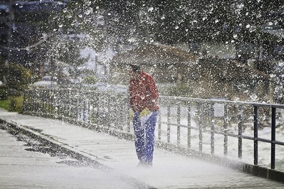
Photo compliments of David Rosen from last December’s big storm
Great spots to get wet include Emma Schmitz Memorial Overlook and Charles Richey Sr View Point (Constellation Park).
Scupper, reporting for Beach Drive Blog
Wet and Windy and…of course… Waves
January 8, 2013 by Leave a Comment
The National Weather Service has issued a Wind Advisory through 4:00 am Wednesday morning. We’re currently heading towards a low tide. However at around 3:00 am, an 11 foot tide is predicted with high tide of 11.2 at 3:45 am Wednesday. The National Weather Service has the winds peaking around midnight, which looks to be around 6:00 ft and should hopefully be a “non-event”.
Here is the Puget Sound Marine forecast:
PZZ135-090830-
PUGET SOUND AND HOOD CANAL-
317 PM PST TUE JAN 8 2013
…GALE WARNING IN EFFECT THROUGH LATE TONIGHT…
TONIGHT…S WIND 25 TO 35 KT…EASING TO 20 TO 30 KT. WIND WAVES 4 TO 6 FT. RAIN.
WED…SW WIND 15 TO 25 KT. WIND WAVES 2 TO 4 FT. RAIN IN THE MORNING…THEN SHOWERS LIKELY.
WED NIGHT…W WIND 10 TO 20 KT…BECOMING SW 5 TO 15 KT. WIND WAVES 1 FT OR LESS. A CHANCE OF SHOWERS. A CHANCE OF SNOW SHOWERS.
National Weather Service Wind Advisory
…WIND ADVISORY NOW IN EFFECT UNTIL 4 AM PST WEDNESDAY…
* SOME AFFECTED LOCATIONS…SEATTLE…BREMERTON…BELLEVUE…
TACOMA…OLYMPIA…FORKS…HOQUIAM…AND THE LAKE LAWRENCE AREA
IN THURSTON COUNTY.
* TIMING…SOUTHERLY WINDS WILL INCREASE THIS EVENING AND PEAK
AROUND MIDNIGHT.
* WIND…LOCAL SUSTAINED WINDS OF 20 TO 35 MPH AND GUSTS OF 45 TO
50 MPH ARE LIKELY.
* IMPACTS…WHILE WINDS OF THIS STRENGTH SHOULD NOT CAUSE
WIDESPREAD DAMAGE…THEY CAN BRING DOWN SMALL TREES AND
BRANCHES. LOCAL POWER OUTAGES ARE POSSIBLE.
SEATTLE/BREMERTON AREA-
INCLUDING THE CITIES OF…SEATTLE…BREMERTON…SILVERDALE…
FEDERAL WAY…KENT
330 PM PST TUE JAN 8 2013
…WIND ADVISORY IN EFFECT UNTIL 4 AM PST WEDNESDAY…
TONIGHT…WINDY…RAIN. RAIN MAY BE HEAVY AT TIMES AFTER MIDNIGHT. LOWS IN THE UPPER 30S TO MID 40S. SOUTH WIND 15 TO 30 MPH WITH GUSTS TO 45 MPH
WEDNESDAY…RAIN AT TIMES IN THE MORNING…THEN RAIN SHOWERS LIKELY IN THE AFTERNOON. HIGHS IN THE 40S. SOUTHWEST WIND 10 TO 20 MPH.
WEDNESDAY NIGHT…CLOUDY. A CHANCE OF RAIN SHOWERS IN THE EVENING… THEN A CHANCE OF RAIN AND SNOW SHOWERS AFTER MIDNIGHT. SNOW LEVEL NEAR 500 FEET AFTER MIDNIGHT. LOWS IN THE LOWER TO MID 30S. SOUTH WIND 10 TO 15 MPH DECREASING TO 10 MPH OR LESS AFTER MIDNIGHT.
Tis the Season for Wet and Windy Winter Weather
December 19, 2012 by Leave a Comment
Monday’s storm was probably one of the worst we’ve personally experienced in our seven years living on Beach Drive. I was surprised to see how many neighbors were hit hard.
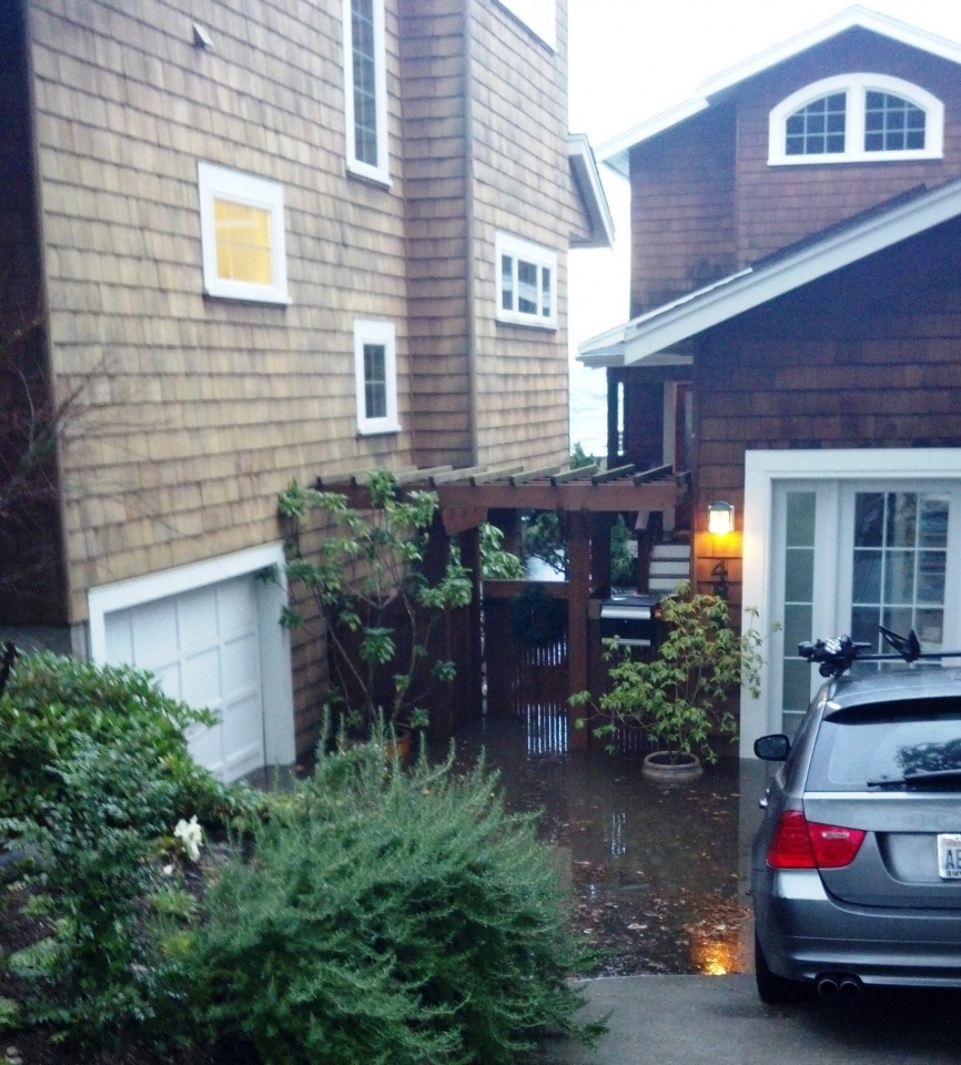
We typically get an extra dose with having a low driveway and neighbors with lower bulkheads. This is one of the reasons why we put together our “barking dog” reports… just warn when we are doing extra preparation for possible flooding. Our built in pump in the driveway is really intended to handle rain and an occasional slurp or splash from the sound.
On Beach Drive Blog, we keep weather related links for your convenience under “Swell Links” to the right. We have more wet and windy wintery weather ahead!
…WINTER WEATHER ADVISORY IN EFFECT UNTIL 10 AM PST THIS MORNING…
REST OF TODAY…WINDY. RAIN AND SNOW IN THE MORNING…THEN RAIN IN THE AFTERNOON. SNOW ACCUMULATION UP TO 2 INCHES. SNOW LEVEL NEAR THE SURFACE IN THE MORNING. HIGHS IN THE UPPER 30S TO MID 40S. SOUTHEAST WIND 15 TO 25 MPH BECOMING SOUTH 15 TO 30 MPH WITH GUSTS TO 40 MPH.
TONIGHT…WINDY…RAIN. LOWS IN THE MID 30S TO LOWER 40S. SOUTH WIND 20 TO 30 MPH WITH GUSTS TO 40 MPH DECREASING TO 10 TO 20 MPH AFTER MIDNIGHT.
THURSDAY…BREEZY. RAIN SHOWERS LIKELY IN THE MORNING…THEN RAIN SHOWERS IN THE AFTERNOON. HIGHS IN THE UPPER 30S TO MID 40S. SOUTHWEST WIND 10 TO 15 MPH BECOMING SOUTH 15 TO 25 MPH IN THE AFTERNOON.
THURSDAY NIGHT…BREEZY. MOSTLY CLOUDY WITH A CHANCE OF RAIN SHOWERS. LOWS IN THE 30S TO LOWER 40S. SOUTH WIND 15 TO 25 MPH DECREASING TO 10 TO 15 MPH AFTER MIDNIGHT.
PUGET SOUND AND HOOD CANAL-
900 AM PST WED DEC 19 2012
…SMALL CRAFT ADVISORY IN EFFECT THROUGH LATE TONIGHT…
TODAY…S WIND 15 TO 30 KT. WIND WAVES 2 TO 4 FT. RAIN…MIXED WITH SNOW OVER HOOD CANAL AND AROUND EVERETT THIS MORNING.
TONIGHT…S WIND 15 TO 30 KT EASING TO 15 TO 25 KT. WIND WAVES 2 TO 4 FT. RAIN.
THU…SW WIND 15 TO 25 KT RISING TO 20 TO 30 KT. WIND WAVES 2 TO 5 FT. SHOWERS.
THU NIGHT…S WIND 15 TO 25 KT EASING TO 10 TO 20 KT. WIND WAVES 1 TO 4 FT.
On a similar note, did you see the Seattle Times article: Record High Tides wash in prospects for more in the future
Was this the worst flooding you’ve experienced?
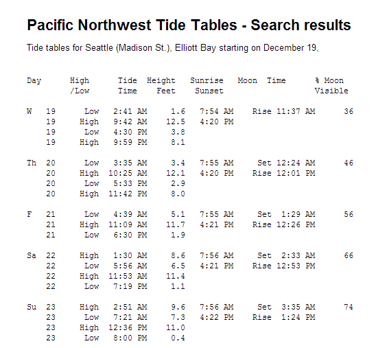
Here are upcoming Seattle tides:


Recent Comments