Barking Dog Report: Gale Watch through Late Tuesday Night

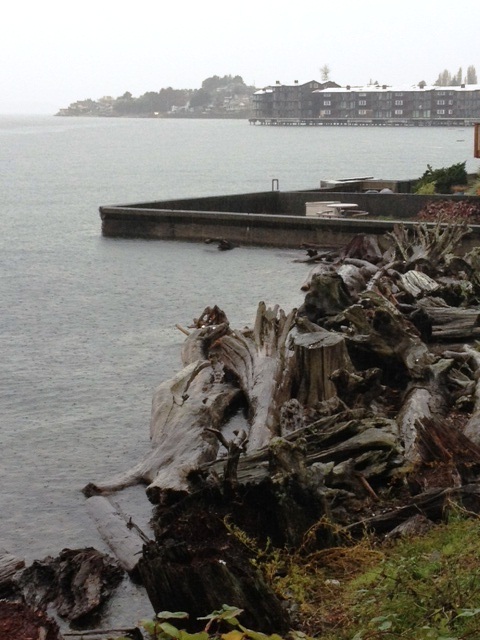
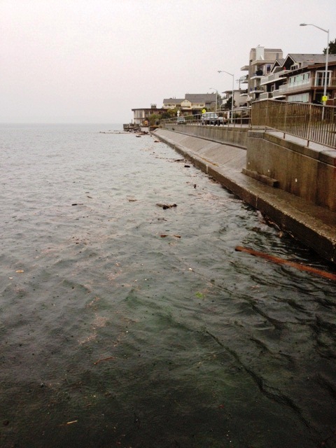
We had a heck of a storm today with waves that just didn’t seem to stop. Some neighbors agree that it’s one of the worst storms they have ever witnessed living on Beach Drive with the waves and wind.

Tomorrow’s forecast looks like it could be more severe that what we experienced today with gusts predicted up to 50 mph around 4:00 pm.

High tide is an est. 12.90 feet at around 8:39 AM; about when the winds are predicted to start shifting to more south – southwest with estimated gusts of around 40 and heading higher.

From Wind Alert as of 3:30 p.m. today.

Puget Sound Marine forecast has not been updated since this morning.

Puget Sound and Hood Canal-
852 AM PST Mon Dec 26 2022

SMALL CRAFT ADVISORY IN EFFECT UNTIL 10 AM PST THIS MORNING GALE WATCH IN EFFECT FROM LATE TONIGHT THROUGH LATE TUESDAY
NIGHT

TONIGHT
E wind 5 to 15 kt rising to 25 to 35 kt after midnight. Wind waves 2 ft or less building to 5 to 7 ft after midnight. Rain.

TUE  S wind 25 to 35 kt. Wind waves 5 to 7 ft. Rain.

TUE NIGHT   SW wind 20 to 30 kt. Wind waves 5 to 7 ft.


So bottom line, this is a “barking dog” report. If tomorrow is anything like today, we anticipate that homes along Beach Drive may be dealing with waves coming over. Stay safe, Neighbors!

Barking Dog Report: Gale Warning starting late tonight

Happy New Years, Neighbors! It looks like 2022 will come roaring in as a storm.

A Gale Warning is in effect starting late tonight along with a Wind Advisory that starts at 10:00 pm tonight through 4:00 p.m. tomorrow.

Wind Alert shows potentially strong gusts in the 40’s pretty much for all of Sunday.

Sunday’s high tides are estimated at:

  • 12.64 feet at 5:28 a.m.
  • 11.95 feet at 3:08 p.m.

Puget Sound Marine Forecast from this morning:

PZZ135-020130-
Puget Sound and Hood Canal-
825 AM PST Sat Jan 1 2022

SMALL CRAFT ADVISORY IN EFFECT THROUGH THIS EVENING
GALE WARNING IN EFFECT FROM LATE TONIGHT THROUGH SUNDAY AFTERNOON

TODAY
S wind 15 to 25 kt. Wind waves 2 to 4 ft.

TONIGHT
S wind 20 to 30 kt. Wind waves 2 to 4 ft. A slight
chance of rain after midnight.

SUN
S wind 25 to 35 kt. Wind waves 4 to 6 ft. Rain.

SUN NIGHT
S wind 20 to 30 kt. Wind waves 4 to 6 ft.

MON
S wind 5 to 15 kt. Wind waves 2 to 4 ft.

MON NIGHT
S wind to 10 kt. Wind waves 2 to 4 ft subsiding to
1 ft or less after midnight.

Stay warm and safe! 

Next! Another windy and wet day.

I’m a little iffy on whether or not this should be an official barking dog report. Yesterday, as my hubby was teasing me for predicting we could flood with the Barking Dog post until late afternoon when the winds seem to suddenly pick up and voila, we had some water splashing over the seawall. Nothing was damaged at our home except for a large flower pot that was too close to the seawall.

Tomorrow looks like we could potentially have some more water slurping over with the higher tides and extended periods of strong winds that have been forecasted.

Tomorrow’s high tides are 12.14 feet at 7:05 am and 11.84 feet at 5:47 pm. It’s possible we could see tides slightly higher. During yesterday’s storm, a coastal flooding warning was issued increasing the tide by 1.1 feet.

Check out Windalerts forecast (as of 2:48 pm 11/5/2021). I’m including the “free version” and the “plus” version (typically we just have the free version). The forecast show similar stories as far as constant strong winds… but the “plus” version on the bottom is showing much stronger winds with gusts in the upper 40’s around 7am vs gusts around 26mph on the free version. I guess we’ll see which one is more accurate tomorrow morning!


Here is the Puget Sound Marine Forecast. Note: 30 knots is about 35 mph.

Puget Sound and Hood Canal-  213 PM PDT Fri Nov 5 2021

SMALL CRAFT ADVISORY IN EFFECT FROM LATE TONIGHT THROUGH SATURDAY EVENING.
TONIGHT: S wind 5 to 15 kt becoming SE to 10 kt after midnight.  Wind waves 2 ft or less. A slight chance of rain in the evening  then rain likely after midnight.
SAT:  S wind 15 to 25 kt rising to 20 to 30 kt in the afternoon.  Wind waves 3 to 5 ft. Rain in the morning then showers and a  slight chance of tstms in the afternoon.
SAT NIGHT:  S wind 20 to 30 kt easing to 5 to 15 kt after  midnight. Wind waves 3 to 5 ft subsiding to 2 ft or less after  midnight. Showers and a slight chance of tstms in the evening  then rain after midnight.

The National Weather Service forecast supports winds in the upper 30s.

Saturday
Rain. High near 47. Breezy, with a south wind 13 to 18 mph increasing to 23 to 28 mph in the afternoon. Winds could gust as high as 39 mph. Chance of precipitation is 80%. New precipitation amounts between a quarter and half of an inch possible.
Saturday Night
Rain. Low around 42. South wind 17 to 21 mph, with gusts as high as 30 mph. Chance of precipitation is 90%. New precipitation amounts between a tenth and quarter of an inch possible.

If you have pumps out, you just might want to keep them out until Monday. Tis the season! 

Barking Dog Report: Gale Warning starting this afternoon

It looks like we’re in for another dose of strong winds and rain. A Gale Warning has been issued starting this afternoon through Thursday evening. The forecasted winds combined with the high tide of 12.05 feet at 4:38 pm today are why we’re calling this a “barking dog report”. If you’re new to Beach Drive Blog, a “Barking Dog Report” is issued when we think there’s a good chance of flooding to occur from wind and waves breeching seawalls or bulkheads. We call it “Barking Dog Report” because it’s just like a neighbors barking dog where there could be trouble or it could amount to nothing at all – it’s just a warning or possibly cause for concern.

Here are details on what is currently in the forecast. Links to the weather or under “Swell Links” on this website and embedded in the post so you can check for updated forecast.

Let’s start with the Gale Warning and Marine Forecast:

Puget Sound and Hood Canal-  235 AM PDT Thu Nov 4 2021

GALE WARNING IN EFFECT FROM NOON PDT TODAY THROUGH THIS EVENING

TODAY S wind 15 to 25 kt rising to 25 to 35 kt in the  afternoon. Wind waves 3 to 5 ft. Rain.

TONIGHT SW wind 25 to 35 kt becoming S 15 to 25 kt after  midnight. Wind waves 3 to 5 ft. Rain in the evening then rain  likely after midnight.

FRI  S wind 20 to 30 kt easing to 15 to 25 kt in the afternoon.  Wind waves 3 to 5 ft. Rain.

Wind Alert for Alki 


You can see on the bottom bar, we’re potentially set to have several windy days! With a high tide of 12.05 feet at 4:38 pm this afternoon, if winds are gusting in the mid to upper 30s, and we have 5 foot waves, we could see significant splashing and water coming over bulkheads.

Again, hopefully we’re just barking about nothing! The forecast may be scaled back as soon as I publish this 😉

Stay safe, neighbors!

High Tides and Winds

It looks like we’re in for another windy day. With a wind advisory in effect until 4:00 pm today and an extra high tide of 12.59 feet at 10:32 this morning.

Here’s the current (8:08 am) Wind Alert forecast. If we do see gusts in the 40s around high tide, it’s quite possible we’ll see some water coming over the bulkhead.


The Puget Sound Marine forecast has a small craft advisory until 10am this morning (last update 2:41 am).

 TODAY  S wind 20 to 30 kt rising to 25 to 35 kt in the  afternoon. Wind waves 3 to 6 ft. Rain.

 TONIGHT  SW wind 15 to 25 kt. Wind becoming NW 10 to 20 kt N  part in the evening and SW 10 to 20 kt S part in the evening.  Wind waves 2 to 4 ft. A chance of rain.

National Weather Service (4:00 am update).

...WIND ADVISORY NOW IN EFFECT FROM 7 AM THIS MORNING TO 4 PM PST
THIS AFTERNOON...

* WIND...Southerly 20 to 35 mph with gusts 45 to 50 mph.

* SOME AFFECTED LOCATIONS...Port Townsend, Everett, Bremerton,
  Seattle, Tacoma, La Push, Ocean Shores, Westport, and Hoquiam.

* IMPACTS...Winds may snap weak branches that have not been
  pruned by recent storms, produce isolated power outages, and
  make the driving of high-profile vehicles difficult.

PRECAUTIONARY/PREPAREDNESS ACTIONS...

A Wind Advisory means that winds of 35 mph are expected. Winds
this strong can make driving difficult, especially for high
profile vehicles. Use extra caution.

We’re not sure if this is going to be a “Barking Dog Report” event where we think there will be flooding along Beach Drive… just something to keep alert about at this point… and we will be past high tide in just over two hours.

Stay tuned!

Barking Dog Report: On Watch for Friday

EDITORS NOTE: Please scroll to the bottom of this post for updates.

If you’re a long time reader of Beach Drive Blog, then you’re most likely familiar with “the Barking Dog Report”. We issue a “Barking Dog Report” when we think there is a strong possibility that our Beach Drive home may flood from waves coming over the bulkhead. Sometimes, much like a neighbors barking dog (and the weatherman), we may be off and there is no issue. However, we think it’s always good to prepare for worse case scenario for those few times that flooding does occur.

For this report, we’re more of a concerned dog that’s sniffing the air for what may come this Friday. What has our ears pulled back this morning? Check out the current data from Wind Alert.


You can see by the bottom graph for this week that we’re going to be in for some stormy, windy weather… however, if Friday’s current forecast holds true, we could have gusts as high as 62 mph around 1:00 pm!

High tide is predicted to be 11.72 feet at 10:12 am on Friday, which is when the wind really appears to start picking up based on this morning’s chart from Wind Alert. At 1:00 p.m., tides are predicted to be around 10 feet…but with winds that strong, waves should be pretty intense.

Again, I hope we’re barking for nothing, just like your neighbor’s dog. It doesn’t hurt to be prepared for a big storm…just in case!

PS: You can follow us on Facebook and Twitter

PS PS: Stay tuned! Weather is such a moving target! As 12:54 pm (a few hours since publishing this post) Wind Alert is showing the strongest gust on Friday to be “only” 46 mph at 4:00 am.

UPDATE: As of 8:00 a.m. December 12, 2018, it looks like Friday will be a non-event. Thursday looks stormy but nothing like what we had originally shared on this post. 🙂


High Tides at Weather Watch and more

Our intrepid reporter Scupper Sr (aka my husband) has been taking photos of local parks during the high tides. 

weather watch
Weather Watch Park

We’ve been keeping a close eye on the tides and strong winds as our property can flood. If we are preparing for flooding, we do our best to issue a “Barking Dog Report”.  This is a term my husband has “fondly” used to describe yours truly when I’m running around the house, worried about pending trouble – such as flooding. Just like your neighbors barking dog, it’s hopefully much ado about nothing… but you never know!

constellation park 2
Constellation Park 

With the recent redesign of Beach Drive Blog, please be sure to check out the “Swell Links” to the left, which features information about pending weather and tides.  And be sure to follow us on Twitter at www.twitter.com/beachdriveblog. If we wind up losing power and not able to post info on the blog, you may find more info on Twitter.

Be prepared, stay warm!  Let’s hope we’re not issuing any “barking dog reports” over this holiday weekend.

Happy Thanksgiving!