 We have another stormy day ahead of us as the remains of Typhoon Songda hits our area. Today’s storm is supposed to be much stronger than yesterday. Currently the National Weather Service has a “storm warning” for the Puget Sound and “high wind warning” for our region. Weather Guru Cliff Mass is warning people to stay away from trees during this storm as branches are likely to come down. Seattle’s Mayor recommends that we stay out of parks this weekend to avoid injury or worse from falling trees.
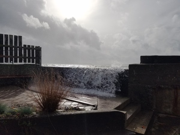
We’re issuing another “Barking Dog Report” because we are preparing for another day of water coming over the bulkhead. Even though the wind direction is not what we typically require for flooding for our home (SW), the winds are predicted to be powerful at the same time of higher tides.
The strongest winds are expected to hit our area in conjunction with higher tides. This afternoon’s high tide is an 11.9 at 4:45 pm.

Here’s the current Puget Sound Marine Forecast:
PZZ135-151900-
PUGET SOUND AND HOOD CANAL-
258 AM PDT SAT OCT 15 2016
SMALL CRAFT ADVISORY IN EFFECT THROUGH THIS AFTERNOON
STORM WARNING IN EFFECT FROM THIS AFTERNOON THROUGH LATE
TONIGHT
TODAY
SE WIND 5 TO 15 KT EARLY…BECOMING E 15 TO 25 KT. WIND WAVES 2 FT OR LESS EARLY…BUILDING TO 2 TO 4 FT IN THE AFTERNOON. RAIN.
TONIGHT
S WIND 30 TO 40 KT WITH GUSTS NEAR 60 KT…EASING TO 20 TO 30 KT AFTER MIDNIGHT. WIND WAVES 5 TO 7 FT…SUBSIDING TO 3 TO 5 FT AFTER MIDNIGHT. RAIN IN THE EVENING…THEN SCATTERED SHOWERS AFTER MIDNIGHT.
High Wind Warning from the National Weather Service:
High Wind Warning
URGENT - WEATHER MESSAGE
NATIONAL WEATHER SERVICE SEATTLE WA
400 AM PDT SAT OCT 15 2016

EVERETT AND VICINITY-TACOMA AREA-HOOD CANAL AREA-
EAST PUGET SOUND LOWLANDS-BELLEVUE AND VICINITY-SEATTLE AND VICINITY-
BREMERTON AND VICINITY-
400 AM PDT SAT OCT 15 2016

...HIGH WIND WARNING REMAINS IN EFFECT FOR THE PUGET SOUND REGION
FROM 3 PM THIS AFTERNOON TO 2 AM PDT SUNDAY...

* WIND...INCREASING FROM THE SOUTH AT 20 TO 35 MPH WITH GUSTS
  LOCALLY NEAR 60 MPH LATE THIS AFTERNOON BEFORE SUBSIDING LATER
  THIS EVENING.

* SOME AFFECTED LOCATIONS...SEATTLE...EVERETT...TACOMA...
  BREMERTON...BRINNON...WOODINVILLE...BELLEVUE...AND SUMNER.

* TIMING...THE STRONGEST WINDS ARE EXPECTED TO OCCUR BETWEEN 4 PM
  AND 9 PM PDT.

* IMPACTS...HIGH WINDS CAN TOPPLE TREES ONTO ROADS...VEHICLES...
  AND ROOFTOPS. FALLING TREES OR LARGE BRANCHES HAVE BEEN KNOWN TO
  CAUSE FATALITIES DURING WINDSTORMS. DOWNED POWER LINES CAN
  CAUSE POWER OUTAGES LASTING A COUPLE OF HOURS OR LONGER.

PRECAUTIONARY/PREPAREDNESS ACTIONS...

SECURE LOOSE OUTDOOR OBJECTS OR LIGHT WEIGHT FURNITURE BEFORE THE
STRONG WINDS ARRIVE. IF THERE IS A POWER OUTAGE, AVOID THE RISK
OF CARBON MONOXIDE POISONING BY KEEPING PORTABLE GENERATORS AND
BARBECUE GRILLS OUTDOORS.
Here’s Wind Alert‘s current chart for predicted winds by Lincoln Park.

Yesterday is old news… however we did experience flooding at our home. It wasn’t nearly as bad as it could have been had the winds been more southwest. Thank you to our wonderful neighbors who stopped by to check on us and help out with the pumps. Our immediate neighbors did not seem to be impacted with flooding yesterday. I posted live videos on Facebook/beachdriveblog.
Stay safe everyone! Charge up those cell phones, check those flashlights for batteries and check on your neighbors. Take care.


Speak Your Mind