Inches of Ice on Jacobsen Road

The base of Jacobsen Road towards Beach Drive is covered with inches of ice.

The Seattle Department of Transportation is on the scene. As we have not had real snow in days, I’m guessing this build up of ice is from the natural springs and our freeeeeezing cold spell.

Bundle up and drive safe, friends!

Barking Dog Report – Round 2: Storm and High Wind Warnings

Barking-Dog-Report
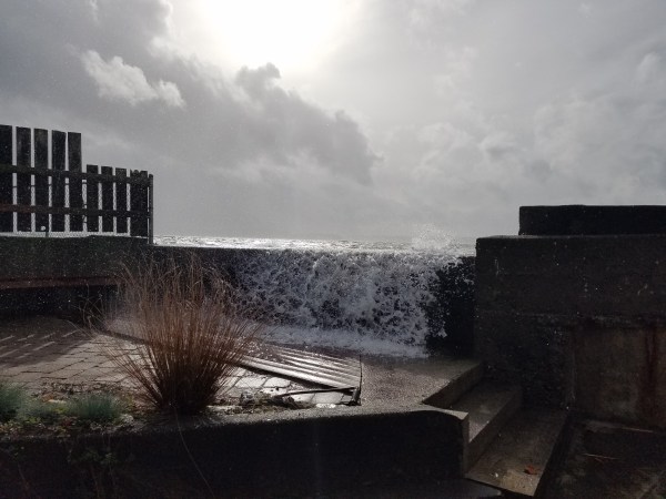
We have another stormy day ahead of us as the remains of Typhoon Songda hits our area. Today’s storm is supposed to be much stronger than yesterday.  Currently the National Weather Service has a “storm warning” for the Puget Sound and “high wind warning” for our region. Weather Guru Cliff Mass is warning people to stay away from trees during this storm as branches are likely to come down. Seattle’s Mayor recommends that we stay out of parks this weekend to avoid injury or worse from falling trees.

We’re issuing another “Barking Dog Report” because we are preparing for another day of water coming over the bulkhead. Even though the wind direction is not what we typically require for flooding for our home (SW), the winds are predicted to be powerful at the same time of higher tides.

The strongest winds are expected to hit our area in conjunction with higher tides. This afternoon’s high tide is an 11.9 at 4:45 pm.

2016-10-15-storm-noaa

Here’s the current Puget Sound Marine Forecast:

PZZ135-151900-
PUGET SOUND AND HOOD CANAL-
258 AM PDT SAT OCT 15 2016

SMALL CRAFT ADVISORY IN EFFECT THROUGH THIS AFTERNOON
STORM WARNING IN EFFECT FROM THIS AFTERNOON THROUGH LATE
TONIGHT

TODAY
SE WIND 5 TO 15 KT EARLY…BECOMING E 15 TO 25 KT. WIND WAVES 2 FT OR LESS EARLY…BUILDING TO 2 TO 4 FT IN THE AFTERNOON. RAIN.

TONIGHT
S WIND 30 TO 40 KT WITH GUSTS NEAR 60 KT…EASING TO 20 TO 30 KT AFTER MIDNIGHT. WIND WAVES 5 TO 7 FT…SUBSIDING TO 3 TO 5 FT AFTER MIDNIGHT. RAIN IN THE EVENING…THEN SCATTERED SHOWERS AFTER MIDNIGHT.

High Wind Warning from the National Weather Service:

High Wind Warning

URGENT - WEATHER MESSAGE
NATIONAL WEATHER SERVICE SEATTLE WA
400 AM PDT SAT OCT 15 2016

EVERETT AND VICINITY-TACOMA AREA-HOOD CANAL AREA-
EAST PUGET SOUND LOWLANDS-BELLEVUE AND VICINITY-SEATTLE AND VICINITY-
BREMERTON AND VICINITY-
400 AM PDT SAT OCT 15 2016

...HIGH WIND WARNING REMAINS IN EFFECT FOR THE PUGET SOUND REGION
FROM 3 PM THIS AFTERNOON TO 2 AM PDT SUNDAY...

* WIND...INCREASING FROM THE SOUTH AT 20 TO 35 MPH WITH GUSTS
  LOCALLY NEAR 60 MPH LATE THIS AFTERNOON BEFORE SUBSIDING LATER
  THIS EVENING.

* SOME AFFECTED LOCATIONS...SEATTLE...EVERETT...TACOMA...
  BREMERTON...BRINNON...WOODINVILLE...BELLEVUE...AND SUMNER.

* TIMING...THE STRONGEST WINDS ARE EXPECTED TO OCCUR BETWEEN 4 PM
  AND 9 PM PDT.

* IMPACTS...HIGH WINDS CAN TOPPLE TREES ONTO ROADS...VEHICLES...
  AND ROOFTOPS. FALLING TREES OR LARGE BRANCHES HAVE BEEN KNOWN TO
  CAUSE FATALITIES DURING WINDSTORMS. DOWNED POWER LINES CAN
  CAUSE POWER OUTAGES LASTING A COUPLE OF HOURS OR LONGER.

PRECAUTIONARY/PREPAREDNESS ACTIONS...

SECURE LOOSE OUTDOOR OBJECTS OR LIGHT WEIGHT FURNITURE BEFORE THE
STRONG WINDS ARRIVE. IF THERE IS A POWER OUTAGE, AVOID THE RISK
OF CARBON MONOXIDE POISONING BY KEEPING PORTABLE GENERATORS AND
BARBECUE GRILLS OUTDOORS.

Here’s Wind Alert‘s current chart for predicted winds by Lincoln Park.

2016-10-15-wind-alert

Yesterday is old news… however we did experience flooding at our home. It wasn’t nearly as bad as it could have been had the winds been more southwest. Thank you to our wonderful neighbors who stopped by to check on us and help out with the pumps. Our immediate neighbors did not seem to be impacted with flooding yesterday. I posted live videos on Facebook/beachdriveblog.

20161014_1459010

Stay safe everyone! Charge up those cell phones, check those flashlights for batteries and check on your neighbors. Take care.

Truck Vandalized on 5600 Block of Beach Drive

A Beach Drive neighbor reports:

My truck was broken into last night. Had a late work day so still had computers and chargers in truck. They took everything plus my workout backpack with gear and running shoes. 5600 block on Beach Drive.

This took place on Friday night. The back side window of the truck was busted out.

Are you missing a boat?

This boat is floating by Emma Schmitz View Point heading north.DSC_0186

Reader asks about park bench replacement at Beach Drive & Jacobsen

A very popular rest stop at the south end of Emma Schmitz Memorial Overlook took a tumble from corrosion back on February 23rd (shouldn’t have eaten that last bite). Neighbors and out-of-towners have enjoyed watching the scenery under the huge “Raptor Tree” that Eagle & Osprey often use to spy on prey. Love that tree!

IMG_5507

Appears that the 2 legged benches are all failing at the weld just under the bench. There a few more with the same design near the drinking fountain that had caution tape applied immediately after the Jacobsen bench toppled . The tape has since come off and the older benches still stand… barely

IMG_5551


The newer 4 legged butt rest looks like a much better design for being near the saltwater…

IMG_5552


As far as replacement, we reported a few years back on plans to rebuild that entire section of the deteriorating seawall. No bench replacement or additions were to happen until the seawall issue gets solved. Construction was intended to start last Summer but the design work was never finalized. A response from the Army Corp of Engineers back in November 2015 didn’t show much progress.

 Unfortunately I don’t have any updates at this point. We are still working through our feasibility phase process before we can move into final design.

I have a current email out to the Army Corp asking for any further progress & will update as soon as they respond.  Meanwhile, the storms keep pounding it and the park department continues to backfill the erosion.

IMG_5542

Picture above taken on the stormy morning of 3/10/16… photo below was furnished by a Beach Drive neighbor the very next morning. Park department workers mentioned that they really didn’t like parking their heavy equipment on the slumping strip of grass which precariously covers  the 54″ sewer line carrying 50 million gallons of sewage per day!

IMG_5549

Scupper, reporting for Beach Drive Blog

Coastal Flooding upgraded to a WARNING

...COASTAL FLOOD WARNING IN EFFECT FROM 2 AM TO 8 AM PST
THURSDAY...

THE NATIONAL WEATHER SERVICE IN SEATTLE HAS ISSUED A COASTAL
FLOOD WARNING...WHICH IS IN EFFECT FROM 2 AM TO 8 AM PST
THURSDAY. THE COASTAL FLOOD ADVISORY IS NO LONGER IN EFFECT.

* COASTAL FLOODING...SALT WATER FLOODING IS LIKELY AROUND THE
  TIME OF HIGH TIDE TONIGHT.

HIGH ASTRONOMICAL TIDES...AUGMENTED BY UNUSUALLY LOW ATMOSPHERIC
PRESSURE...WILL LIKELY FLOOD VERY LOW LYING COASTAL AREAS.
NORMALLY...FLOODING WITH THE TIDES WOULD BE MINOR. HOWEVER...
WINDS WILL WHIP UP WAVES OF 4 TO 6 FEET AROUND THE TIME OF HIGH
TIDE WITH WATER COMING OVER SEAWALLS AND IMPACTING STRUCTURES IN
LOW LYING AREAS NEAR THE WATER. FLOODING IS EXPECTED AROUND
THE TIME OF HIGH TIDE.

THE TABLE BELOW GIVES TIME AND HEIGHT OF PREDICTED TIDES...THE
PREDICTED TIDAL ANOMALY DUE TO LOW PRESSURE AND OTHER FACTORS...
AND THE SUM OF THE PREDICTED TIDE AND THE PREDICTED ANOMALY.

STATION NAME: DAY  TIME     PRED   ANOMALY TOTAL TIDE
 SEATTLE      THU 05:38 AM 12.44    ~1.9     14.3
 PORT TOWNSND THU 05:12 AM  8.99   ~ 1.9     10.8
 FRI HARBOR   THU 05:53 AM  7.89   ~ 1.9      9.7
 CHERRY PT    THU 06:12 AM  9.48   ~ 1.9     11.3

* IMPACTS...FLOODING IN LOW LYING COMMUNITIES NEAR ALONG THE
  PUGET SOUND AROUND HIGH TIDE. WAVES MAY DAMAGE STRUCTURES
  IN LOW LYING AREAS ALONG THE SOUND.

PRECAUTIONARY/PREPAREDNESS ACTIONS...

A COASTAL FLOOD WARNING MEANS THAT FLOODING IS OCCURRING OR
IMMINENT. COASTAL RESIDENTS IN THE WARNED AREA SHOULD BE ALERT
FOR RISING WATER...AND TAKE APPROPRIATE ACTION TO PROTECT LIFE
AND PROPERTY.

Slow down with Proposition 1 …opinion

SDOT’s new levy project to move most of Seattle sounds like another great plan for West Seattle (remember the monorail Green Line?). Status quo with more bike lanes and speed enforcement is exactly what we need! Let’s take closer look at each enhancement…

Fauntleroy WayKey elements include paving, adding a protected bike lane, transit enhancements, and signal upgrades, improving safety and reliability for all travelers. Sounds terrific for Vashon Island comutters. How much $ are they contributing again??

Roxbury Street & 35th AveOver the last three years, 294 collisions, 128 injuries, and 2 fatalities have occurred. We are currently planning and designing near-term safety improvements paired with education and enforcement, working towards the city’s Vision. I believe a majority of these accidents occur from drivers slamming on their breaks trying to avoid the traffic-cop camera’s mailing out $190 tickets for doing 22 in a 20mph School Zone… when lights are flashing or children present or distracted by taking your eyes off the road to get a read on the myriad of signs designed to “educate us”.

SW Alaska Street:  The levy would provide funding to make safety improvements like redesigning the roadway. That’s an easy one. Just put the design back to where it was before adding the “bus only” & the staggered right turn only lane. Can you imagine being an out-of-towner trying to drive that stretch all the way to the junction?

Admiral Way: Project Goals

  • Encourage slower speeds  Tell that to the bikers doing 40 mph down the hill.
  • Reduce collisions  Collisions happen.
  • Accommodate existing maximum on-street parking occupancy There’s plenty of occupancy in motor homes & vans along Beach Drive.
  • Provide a comfortable and predictable bike connection between Alki and California Ave business district Why just bikes?

Here’s a more comprehensive plan that’s much more inclusive to our residents…

Admiral_proposal


The rest of the levy just repairs what we already have at a cost of $275 per year per household (median household of 450K) as opposed to the $130 we’re currently paying with the Bridge the Gap levy.

I’m convinced that the rest of the city just believes we West Seattleites love a good parade and need to slow down. While crawling in traffic between Admiral & Fauntleroy junctions yesterday, I reminisced of escorting my HiYu princess along California Ave. I wanted to roll down my window and give the float wave to all the angry impatient drivers heading the other way.

If you ask me, the rest of the city better look out. Old timers tell us it only took 71 years to get the high level bridge over the Duwamish!

Seattleites endured in trying to secure a high-level bridge that would get them to and from “the mainland” without being held up by boat traffic along the Duwamish River.

West Seattleites began campaigning for the bridge in 1916 and at one point threatened to secede from the city if it didn’t deliver.

Thank goodness we now have the West Seattle Bridge. Where else can you sit in traffic all day, soak in the wonderful views and dream of the day Starbucks can land a 4th cup of jo on your car hood’s drone pad.

They first named Alki “little New York” when the city founders came ashore. Now with all the new high density residential buildings coming on-line, we are becoming the “little Manhattan Island” of Seattle and could use a transportation plan that helps us get around.

IMG_5254

Scupper, blathering opinions on Beach Drive Blog (My wife, the blog boss, only allows me 1 opinion per year!)

1917 Atlas clearly shows Carroll Street Pier

I’ve been fascinated for years about the maritime history of Weather Watch Park. A plaque at the park describes how a long pier serviced passengers via the infamous Puget Sound Mosquito Fleet . In a blog post from 2013, we researched city/county archives & local museums looking for any photos or maps that would clearly establish the piers existence. There wasn’t much there except verbal accounts from a long time resident and a few vintage NOAA charts with a dark line jutting out.

I recently gave it another shot by emailing the Seattle Public Library’s at ASKspl.org (thanks Suky!). Within a day or so, I received an email with this 1917 Sanborn Atlas which clearly shows the area landmarks…

pier
A close up look not only shows the named pier but also a small Public Comfort Station at the head of the dock! Following east along Carroll Street, you can see the old locations of the Alki Congregational Church & the Fire Dept/Hall across the north side of the street.


CarrollStPier
I just love this stuff.


Scupper, reporting for Beach Drive Blog

Wooo weeeeee! “Fauntleroy stench” stink’n up the beaches

Don’t blame it on the dog or over clean the cat box. This mornings low tides and the lack of a good breeze is making it nearly unbearable around Beach Drive. Rotting seaweed or sea lettuce is busy emitting hydrogen sulfide into the air we breath.

The term “Fauntleroy stench” was coined back in the late 1980’s when the the cove and other areas around the sound experienced this same rotten egg sensation. The Seattle Times wrote an article about it during the hot summer 1998 when Fauntleroy residents were complaining of headaches and nausea due to the strong odors.

In small amounts, the gas can burn the eyes, nose and throat, according to the federal Centers for Disease Control and Prevention. In moderate amounts, it can bring on headaches, dizziness, nausea, vomiting and respiratory problems.

Contrary to what you might think, opening windows and doors while running fans is the best way to purge the scourge from your home.

Some experts believe that a mild winter combined with a prolonged hot summer is the yummy recipe to bring the stench. If that’s the case, next year could be a real duesey! I just think it smells like Labor Day.

seaweed


Scupper, reporting for Beach Drive Blog

Wind, Waves and Rain

The weather forecast for tomorrow is concerning enough for us to pull anchor on our boats to move them to more protected areas. Here’s what we’re looking at that’s causing us to take this action:

We have a gale warning in effect through Sunday evening.

This is from the Puget Sound Marine Forecast:

 SAT  SOUTH WIND 10 TO 15 KT…BECOMING S 25 TO 35 KT IN THE  AFTERNOON. WIND WAVES 1 OR 2 FT…BUILDING TO 4 TO 6 FT IN THE  AFTERNOON. RAIN.  

SAT NIGHT  S WIND 10 TO 20 KT…EASING TO 10 KT AFTER MIDNIGHT.  WIND WAVES 1 TO 3 FT…SUBSIDING TO 1 FT OR LESS AFTER MIDNIGHT.  SHOWERS IN THE EVENING…THEN A CHANCE OF SHOWERS AFTER MIDNIGHT.

The National Weather Service has issued a wind advisory.

THE NATIONAL WEATHER SERVICE IN SEATTLE HAS ISSUED A WIND ADVISORY…WHICH IS IN EFFECT FROM 11 AM TO 5 PM PDT SATURDAY. * TIMING…MIDDAY THROUGH SATURDAY AFTERNOON. * WINDS…SOUTH WIND 15 TO 30 MPH WITH GUSTS TO 45 MPH. * IMPACTS…DOWNED LIMBS AND LOCAL POWER OUTAGES. PRECAUTIONARY/PREPAREDNESS ACTIONS… A WIND ADVISORY MEANS THAT WINDS OF 35 MPH ARE EXPECTED. WINDS THIS STRONG CAN MAKE DRIVING DIFFICULT…ESPECIALLY FOR HIGH PROFILE VEHICLES. USE EXTRA CAUTION.


Saturday
Rain. High near 68. Breezy, with a northeast wind 6 to 11 mph becoming south 18 to 28 mph in the morning. Winds could gust as high as 39 mph. Chance of precipitation is 100%. New precipitation amounts between a quarter and half of an inch possible.
Saturday Night
Showers, mainly before 11pm. Low around 56. South wind 16 to 21 mph decreasing to 9 to 14 mph after midnight. Winds could gust as high as 29 mph. Chance of precipitation is 90%. New precipitation amounts between a quarter and half of an inch possible.
SATURDAY…WINDY…RAIN. RAINFALL AMOUNTS A QUARTER TO A HALF INCH POSSIBLE. HIGHS IN THE MID 60S TO LOWER 70S. SOUTH WIND AROUND 10 MPH INCREASING TO 20 TO 35 MPH WITH GUSTS TO 45 MPH IN THE AFTERNOON.

SATURDAY NIGHT…BREEZY. SHOWERS IN THE EVENING…THEN MOSTLY CLOUDY WITH A CHANCE OF SHOWERS AFTER MIDNIGHT. LOCALLY HEAVY RAINFALL POSSIBLE IN THE EVENING. RAINFALL AMOUNTS A HALF INCH TO ONE INCH POSSIBLE. LOWS IN THE 50S. SOUTH WIND 15 TO 25 MPH DECREASING TO AROUND 10 MPH AFTER MIDNIGHT.

Tides will be rising from a -1.02 at 11:05 am tomorrow to an 11.73 at 5:47 pm tomorrow – just in time for the wind! From NOAA:

2015-08-28_1906